![](/images/other/stat-length.png)
![Randonnée Randonnée équestre Le Pontet - 202406 boucle Vallée des Huiles - Photo](https://media.geolcdn.com/t/1900/400/ext.pjpeg?maxdim=2&url=https%3A%2F%2Fstatic1.geolcdn.com%2Fsiteimages%2Fupload%2Ffiles%2F1524743154cheval.jpg)
202406 boucle Vallée des Huiles
xhakon
Utilisateur
![Longueur](/images/other/stat-length.png)
Longueur
33 km
![Altitude max](https://static1.geolcdn.com/siteimages/upload/files/1508320355ic_sort_altitude_max_24dp.png)
Altitude max
1388 m
![Dénivelé positif](https://static1.geolcdn.com/siteimages/upload/files/1508320355ic_sort_den_pos_24dp.png)
Dénivelé positif
1292 m
![Km-Effort](/images/other/stat-length.png)
Km-Effort
50 km
![Altitude min](https://static1.geolcdn.com/siteimages/upload/files/1508320355ic_sort_altitude_min_24dp.png)
Altitude min
672 m
![Dénivelé négatif](https://static1.geolcdn.com/siteimages/upload/files/1508320355ic_sort_den_neg_24dp.png)
Dénivelé négatif
1294 m
![Boucle](https://static1.geolcdn.com/siteimages/upload/files/16400158638029165_repeat_loop_refresh_sync_direction_icon.png)
Boucle
Oui
Date de création :
2024-06-30 07:00:11.348
Dernière modification :
2024-06-30 14:58:48.922
![Randonnée équestre](https://static1.geolcdn.com/sitytour/trail-icons/301.png)
6h00
Difficulté : Difficile
![Scannez ce code QR pour ouvrir la randonnée dans l'application SityTrail](https://capi.geolives.com/qq0zvz2zws4bq2lad0pu/sitytour/trails/4107660/qr.png?size=200)
Application GPS de randonnée GRATUITE
À propos
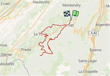
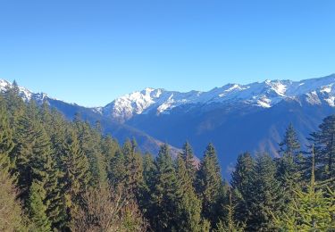
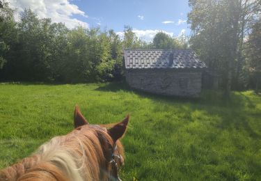
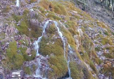
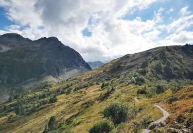
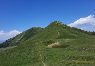
Randonnée Randonnée équestre de 33 km à découvrir à Auvergne-Rhône-Alpes, Savoie, Le Pontet. Cette randonnée est proposée par xhakon.
Description
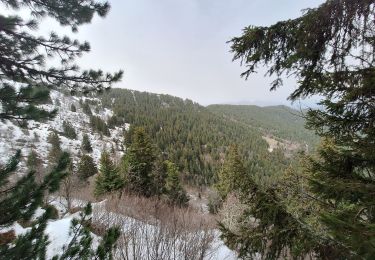
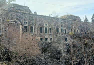
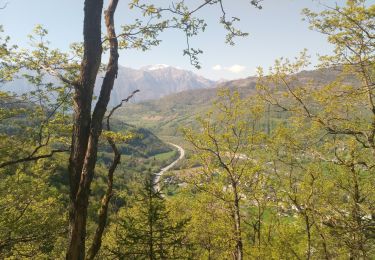
Grande boucle avec de beaux passages.
Mais quand-même une montée vraiment trop longue et raide, et une descente encore plus longue sur une piste large.
Localisation
Pays :
France
Région :
Auvergne-Rhône-Alpes
Département/Province :
Savoie
Commune :
Le Pontet
Localité :
Unknown
Départ:(Dec)
Départ:(UTM)
284379 ; 5042311 (32T) N.
Commentaires
Randonnées à proximité
![Randonnée Marche Saint-Alban-d'Hurtières - Col Clampet, Le Grand Chat, Col d'alarmant - Photo](https://media.geolcdn.com/t/375/260/1d513b6f-1761-484e-9270-d816dd50c7b3.jpg&format=jpg&maxdim=2)
![Marche Marche](https://static1.geolcdn.com/sitytour/trail-icons/101.png)
Col Clampet, Le Grand Chat, Col d'alarmant
Marche
Facile
Saint-Alban-d'Hurtières,
Auvergne-Rhône-Alpes,
Savoie,
France
![](/images/other/stat-length.png)
8,4 km | 15,5 km-effort
3h 15min
![](https://static1.geolcdn.com/siteimages/upload/files/16400158638029165_repeat_loop_refresh_sync_direction_icon.png)
Oui
![Randonnée Marche Montgilbert - les batteries par Montgilbert - Photo](https://media.geolcdn.com/t/375/260/f104cb28-96a4-49e7-af5f-60f831324464.jpg&format=jpg&maxdim=2)
![Marche Marche](https://static1.geolcdn.com/sitytour/trail-icons/101.png)
les batteries par Montgilbert
Marche
Facile
Montgilbert,
Auvergne-Rhône-Alpes,
Savoie,
France
![](/images/other/stat-length.png)
11,5 km | 19,5 km-effort
3h 10min
![](https://static1.geolcdn.com/siteimages/upload/files/16400158638029165_repeat_loop_refresh_sync_direction_icon.png)
Oui
![Randonnée Marche Saint-Georges-d'Hurtières - la lechere/plan du bourg- Val d'arc - Photo](https://media.geolcdn.com/t/375/260/6b5589cc-1116-407d-9f87-08d7001f11fb.jpg&format=jpg&maxdim=2)
![Marche Marche](https://static1.geolcdn.com/sitytour/trail-icons/101.png)
la lechere/plan du bourg- Val d'arc
Marche
Moyen
Saint-Georges-d'Hurtières,
Auvergne-Rhône-Alpes,
Savoie,
France
![](/images/other/stat-length.png)
5,7 km | 10,5 km-effort
1h 19min
![](https://static1.geolcdn.com/siteimages/upload/files/16400158638029165_repeat_loop_refresh_sync_direction_icon.png)
Non
![Randonnée Marche Saint-Georges-d'Hurtières - batterie de roche brune - Photo](https://media.geolcdn.com/t/375/260/a2e3856d-1af7-4c6a-b02e-75503bd26687.jpg&format=jpg&maxdim=2)
![Marche Marche](https://static1.geolcdn.com/sitytour/trail-icons/101.png)
batterie de roche brune
Marche
Moyen
Saint-Georges-d'Hurtières,
Auvergne-Rhône-Alpes,
Savoie,
France
![](/images/other/stat-length.png)
4,5 km | 10,3 km-effort
1h 56min
![](https://static1.geolcdn.com/siteimages/upload/files/16400158638029165_repeat_loop_refresh_sync_direction_icon.png)
Oui
![Randonnée Randonnée équestre Le Pontet - 202405 boucle BourgetEnHuile - ColGrandCucheron - Photo](https://media.geolcdn.com/t/375/260/02b13f43-35f1-41c6-b4a1-cff4d607bf4a.jpg&format=jpg&maxdim=2)
![Randonnée équestre Randonnée équestre](https://static1.geolcdn.com/sitytour/trail-icons/301.png)
202405 boucle BourgetEnHuile - ColGrandCucheron
Randonnée équestre
Difficile
(1)
Le Pontet,
Auvergne-Rhône-Alpes,
Savoie,
France
![](/images/other/stat-length.png)
16,9 km | 28 km-effort
4h 30min
![](https://static1.geolcdn.com/siteimages/upload/files/16400158638029165_repeat_loop_refresh_sync_direction_icon.png)
Oui
![Randonnée Marche Montgilbert - source des 7 fontaines - Photo](https://media.geolcdn.com/t/375/260/2bc8909d-9444-4814-8dd4-507cca075d20.jpg&format=jpg&maxdim=2)
![Marche Marche](https://static1.geolcdn.com/sitytour/trail-icons/101.png)
source des 7 fontaines
Marche
Très facile
Montgilbert,
Auvergne-Rhône-Alpes,
Savoie,
France
![](/images/other/stat-length.png)
13,5 km | 19 km-effort
1h 47min
![](https://static1.geolcdn.com/siteimages/upload/files/16400158638029165_repeat_loop_refresh_sync_direction_icon.png)
Non
![Randonnée Marche Saint-Alban-d'Hurtières - 20220904 - Col du Champet / Col d'Arbarétan - Photo](https://media.geolcdn.com/t/375/260/589ac00e-7357-4b6b-8b10-9bd5eacea9a3.jpg&format=jpg&maxdim=2)
![Marche Marche](https://static1.geolcdn.com/sitytour/trail-icons/101.png)
20220904 - Col du Champet / Col d'Arbarétan
Marche
Très difficile
Saint-Alban-d'Hurtières,
Auvergne-Rhône-Alpes,
Savoie,
France
![](/images/other/stat-length.png)
10,1 km | 17 km-effort
4h 40min
![](https://static1.geolcdn.com/siteimages/upload/files/16400158638029165_repeat_loop_refresh_sync_direction_icon.png)
Oui
![Randonnée Marche Saint-Alban-d'Hurtières - Le Chapotet par le Grand Chat - Photo](https://media.geolcdn.com/t/375/260/2d2f839c-db64-4191-a643-58d018fa9929.jpg&format=jpg&maxdim=2)
![Marche Marche](https://static1.geolcdn.com/sitytour/trail-icons/101.png)
Le Chapotet par le Grand Chat
Marche
Difficile
Saint-Alban-d'Hurtières,
Auvergne-Rhône-Alpes,
Savoie,
France
![](/images/other/stat-length.png)
13,6 km | 25 km-effort
6h 15min
![](https://static1.geolcdn.com/siteimages/upload/files/16400158638029165_repeat_loop_refresh_sync_direction_icon.png)
Oui
![Randonnée Marche Saint-Alban-d'Hurtières - col du GD cucheron / les granges - Photo](https://media.geolcdn.com/t/375/260/132b6e5c-339e-4b20-aee2-77fb8c43db4b.jpg&format=jpg&maxdim=2)
![Marche Marche](https://static1.geolcdn.com/sitytour/trail-icons/101.png)
col du GD cucheron / les granges
Marche
Moyen
Saint-Alban-d'Hurtières,
Auvergne-Rhône-Alpes,
Savoie,
France
![](/images/other/stat-length.png)
13,4 km | 20 km-effort
5h 15min
![](https://static1.geolcdn.com/siteimages/upload/files/16400158638029165_repeat_loop_refresh_sync_direction_icon.png)
Non